2013 November 6
Drove south from Page, Arizona toward China Valley. Along the way we found two additional national monuments.
Wupatki National Monument is the site of the ruins from Indian peoples that lived in the area from prehistoric times up to 1200 a.d. Set in the high desert country in Arizona it is also part of the painted desert. The buildings were interesting in that many of them were erected on the top of stones, or a group of stones. The walls of the structures wrapped around the stones and almost seemed to emerge from them.
This was also a volcanic area. Lots of lava rock and black ash in the soil. The volcano last erupted in 1024 (I may have to verify this date).
Sunset Crater National Monument was just south of Wupatki. In fact, there was a park road connecting them. This was the home of the volcanoes that spewed all the lava and ash. We basically drove through this park without stopping to look at anything. Took pictures from the truck.
The rest of our day was spent driving to Chino Valley, Arizona to spend the next few days with friends, Lloyd and Carol Jones.
Wednesday, November 6, 2013
Tuesday, November 5, 2013
2013 November 5
Another day, another national park! Today was Zion National Park. Again very beautiful and very different from the others that we've visited.
The highlights were the river-walk trail. Very scenic. There were many trees that still had their leaves, mostly yellow. Many opportunities to take pictures.
Along this trail we came upon a family of deer, the antlered stag, a doe, and a fawn. They were 20-30 feet from us and did not seem to have any fear as long as we didn't make sudden moves.
Drove through a mile-long tunnel that passed through Mt Carmel in the park.
We are in Page, Arizona tonight. Tomorrow will drive to Chino Valley, Arizona to spend a few days with friends before starting the drive home......
Monday, November 4, 2013
2013 November 4
Went to Bryce Canyon National Park today. I am amazed at how different these parks are when they really are not that far apart. The color at Bryce was the first thing that I noticed. Instead of the red color we'd been seeing, it was more coral. It was very cold this morning. In the upper 20s when we were in the park. We spent most of the time at 8000 - 9000 feet. The sun finally came out from behind the clouds which helped, at least psychologically.
The views were fantastic again. I walked a mile loop through a forested area to see views not available from the general viewing area at Rainbow Point. Saw two "Bear Alerts" posted. Didn't see any tracks, but was super aware of my surroundings.
When we left the park, drove to Hurricane, Utah for the night. At one of the high points along the highway, did encounter snow flurries. It was very windy when we reached our
nightly accommodations. The clerk said the winds were commonplace for the area, hence the name "hurricane".
Another park is on the agenda for tomorrow, Zion National Park. Tomorrow night we should be just across the border in Page, Arizona. This will be our last night on the road before we get to Chino Valley, Arizona to spend a few days with Lloyd and Carol Jones.
Sunday, November 3, 2013
2013 November 3
One of the best days of the trip! Slept in and had a relaxed start to the day...drove to Capitol Reef National Park. I really don't recall having heard of this one until recently when I watched the Ken Burns documentary on the National Parks. It is beautiful. We walked in a gully between sheer rock walls along an old wagon train route. Then we were on top of a mesa looking down into the valleys. Again, when you are at any elevation, you can see "forever"!
We delayed arrangements for our stay tonight because we were not sure far we would drive after leaving the park. We also were out of cell phone service range for most of the day. Drove on State Road 12 toward Bryce Canyon National Park. Outstanding! Went over Boulder Mountain peaking at 9800 feet. From there could look back to Capital Reef NP area. Part of the road we drove on the ridge with both sides of the road sloping down into canyons below. That section was called Hogs Back. Were in and out of parts of the Dixie National Forest. Were delayed along the road as a small heard of longhorn cattle were herded across the road. Two of the young bulls were butting horns next to our truck. Drove through several beautiful valleys and then into the Bryce Canyon area. One of the most scenic roads we've traveled.
We are staying in Panguitch, Utah tonight. Bryce Canyon NP tomorrow. Maybe Zion NP as well, depends on how much time we spend in Bryce.
Loving this trip. Every day has been something new.
Saturday, November 2, 2013
2013 November 2
Today we started at Arches National Park. It is really something. There is a lot to see. There is some walking involved. Saw the arches used as images most identified with the park, Delicate Arch and Architectural Arch. There is way more to the park. We were there about 5 hours and didn't see everything. Met up with a couple that was originally from Iowa, now Utah. This was their 6th trip to the park and the first time that they had reached the Architectural Arch.
Next we drove to the northern part of Canyonlands National Park. The park is divided into three separate sections by the Green River and the Colorado River. The rivers meet in the park. There are no bridges in the park over the rivers. The section that we visited had one of the most noticeable formation from this park, Mesa Arch. If you received an email from me today, I sent two pictures from the park. Duane is standing in front of Mesa Arch.
We are blown away by the beauty of this part of our country. The scenery is
impressive, every roadway, every park has something different to offer. There is more color in the landscapes than I had expected. The vastness of vistas is had to comprehend. I have a hard time guessing how far in the distance a rock formation or mountain might be. It could be 40, 50, 60, or even 70 miles!
2013 November 1
Big day today. Went to Natural Bridges National Monument. There were three bridges formed of stone by the Colorado River. They were quite spectacular. There were hiking trails that would take you closer to the bridges. We walked about half way on one of the trails. The trail was not paved. We were winded due to the exertion and the altitude. Views were still fantastic.
Next on to Goosenecks State Park. The Goosenecks is one of the most striking and impressive examples of an entrenched river meander on the North American continent. The San Juan River twists and turns through the meander, flowing a distance of over six miles while advancing only one and one-half miles west toward Lake Powell. What we saw took over 300 million years of geologic activity. Incredible!
Next we took a very scenic drive on Highway 261. There is a three mile section that is known as the Moki Dugway. It winds its way 1200 feet from the valley to the Cedar Mesa. Slopes as steep as 11 degrees. There are a number of switchbacks. Duane loved driving this! From the top you can see much of the Four Corners region of the southwest - Sleeping Ute Mountain in Colorado; Shiprock near Shiprock, New Mexico; the Carrizo Mountains on the New Mexico and Arizona border; and Monument Valley that crosses the Utah and Arizona border.
We had plans to see part of Canyonlands National Park but were too late in the day, so finished
driving to our "home" for the night in Green River, Utah.
Thursday, October 31, 2013
2013 October 31
Another day filled with awesome scenery.... It was cold when we woke up. 22 degrees. There was a dusting of snow during the night. We drove to Mesa Verde National Park. Highly recommend this to anyone who has the opportunity to see it. This is the place that many of the Pueblo people in this area (1200-1300a.d.) lived in cliff dwellings. They were not rediscovered until early in the 1900s. We were able to use stairs to reach the dwellings. They would have used notches in the wall of the cliff. The altitude was similar to the area we visited in Peru earlier this year, Cusco and Machu Picchu, around 8000 ft.
A lovely drive along highway 160 took us to the Four Corners. This is where the states of Colorado, Utah, Arizona and New Mexico come together.
The end of our driving today brought us to Blanding, Utah. The plan tomorrow is to see the Valley of the Gods, the Natural Bridges National Monument, and Canyonlands National Park. There are also some individual rock formations along the way that we are hoping to view. Tomorrow night may be Moab, Utah.
Wednesday, October 30, 2013
2013 October 30
This morning we went to Great Sand Dunes National Park. These dunes are up to 700 foot high at the base of the mountains! Incredible scenery. There is also a nature preserve on the park grounds. Saw deer wandering through the park, like the bears in Yellowstone. Just outside the park we went to Zapata Falls. Actually we only heard the falls after walking to their location. To see them we would have had to walk across the water and slippery rocks. As the air temperature was in the low 30s, we were sure that water was colder. There was also supposed to be a lake. We followed that trail for over a mile, up the mountain, over a rocky path and finally decided it was more than we were prepared to finish. So we ended up with some great exercise and pictures of our trek, but no waterfall and no lake!
The afternoon was spent traveling to our next overnight stay in Durango. That meant we drove scenic highway 160 over the mountains via the Wolf Creek Pass. At the top the temperature outside was 22 degrees and the snow was falling. The snowplow was out clearing the roads. Went through two tunnels, saw some outstanding scenery and were glad to have successfully completed the trip.
Tomorrow will be Mesa Verde National Park for sure. The four corners are possible. We will end up somewhere in Utah near Canyonlands National Park. There are a number of scenic spots to see along the way.
Still having issues with inserting pictures to the blog. Will continue telling the story.
Tuesday, October 29, 2013
2013 October 29
Yesterday we started our trip to the southwest. Planning to see many of the national parks on our scenic route to Chino Valley, Arizona. Plan to spend some time with friends in Arizona before finding a new route to return home around the middle of November.
This morning we were in Dodge City, Kansas where we spent our first night on the road. We toured a museum that included some original buildings, Boot Hill Cemetery, a saloon, store fronts, and many items from historical Dodge City.
On the way "out of Dodge" we stopped at a place where we were to see wagon wheel ruts from the many wagon trains that traveled the Sante Fe Trail. The trail wasn't that obvious to us.... but the information at the site was interesting. Apparently, this area was on the border between the US and Mexico. The 100th meridian.
Then we drove through the rest of western Kansas and into Colorado. In Kansas we saw many sorghum fields, a few sunflower fields, a farm that raised game birds (pheasants, etc.), and many large cattle feeding stations (ranches). Not many trees along the way.... lots of open land. Into Colorado there were some changes in scenery. At first, more trees, then different types of shrubbery, then finally, mountains. We thoroughly enjoyed the views and are looking forward to the rest of our trip.
We are spending our second night in Alamosa, Colorado. We are only 35 miles from our first national park. First thing on tomorrow's agenda is Great Sand Dunes National Park!
Having trouble uploading pictures...... will try to figure out what the problem is..... wish I was more techy!!
Thursday, February 14, 2013
Feb 14 last posting for awhile
Since it takes lots of internet time to post pictures.... I will be putting most of them from this point forward on Sam's blog site. I may just add additional information, stories, etc. on this site. But there will be few pictures.
We get off the ship for a couple of days starting at 8 a.m. tomorrow. The big excursion to Machu Picchu. Hope to have at least one awesome picture to prove we were there.
We get off the ship for a couple of days starting at 8 a.m. tomorrow. The big excursion to Machu Picchu. Hope to have at least one awesome picture to prove we were there.
Tuesday, February 12, 2013
Feb 9 - Guatemala
After a late arrival at the Port of Quetzal in Guatemala and
mass confusion while getting off the ship, we rode a bus to the city of
Antigua. Along the way we saw three volcanoes. One was dormant, the other two
were active. There were banana and sugar cane fields along the way. We stopped
in a little village of San Antonio Aguas Calientes to see a textile cooperative.
Here is a picture of a taxi that was used locally.
+San+Antonio+taxi.JPG)
Duane and Karen in front of the church in San Antonio. Hope
that you can see some of the hillside in the background. The people cultivated,
by hand, plots of land all the way up the side of the hill.
+San+Antonio+church+Duane+&+Karen.jpg)
Antigua, Guatemala used to be the capital of the country.
After several earthquakes throughout the years, the people were tired of
rebuilding the town. So they abandoned it and established their capital in
Guatemala City. Some of the older people wanted to go back to Antigua as they
had been born and raised there. The city
is a national historical treasure and there are restrictions on new buildings
in the town center. At one time there were 30-40 churches in the town. The
earthquake ruins of many of those churches are still visible. We are lunch at
an old building that had been a convent. It was restored, in part, and is now
used as a hotel and restaurant as well as a historical site. The next two
pictures are from an area I think was originally the chapel in the convent. You
can see that the partially crumbled wall, has been filled in with glass. All
the original wooden doors are still in place below the windows.
+Antigua+-+Santa+Domingo.JPG)
+Antigua+-+Santa+Domingo.JPG)
The chimes in this picture are to alert inhabitants of an
earthquake. They were massive. My guess is 30-40 foot top to bottom.
+Antigua+-+Earthquake+chimes.JPG)
I had more pictures that I wanted to share from this excursion, but the internet connection, although it says it is excellent, has been very slow.
Saturday, February 9, 2013
Feb 8 Huatuco, Mexico
Port of Huatulco, Mexico. We went white water rafting (level
1) today. It was a very scenic river. Rapids were fun but not challenging.
There were many species of birds. Pictures from the excursion are on the other
camera. Not sure how that I can transfer them from the camera to the laptop.
+Huatulco,+Mexico.JPG)
2013-02-06 Dolphins and sunset
From our balcony, we spotted a couple pods of dolphins
swimming near the ship. I’m not sure how well they can be seen in this photo
that I am posting, but there are probably 10-12 in the picture. We saw whales yesterday and some sea-turtles
as well.
+dophins+-+port+side.JPG)
We had a window seat in the dining room tonight and enjoyed
this sunset.
+sunset+while+dining.JPG)
+sunset+while+dining.JPG)

It was formal night on the ship. This is as “dressed up” as
we will be on the cruise.
+duane+karen+-+formal+night.JPG)
Cabo San Lucas, Mexico
Here are a couple of pictures of the entrance to the harbor area in Cabo San Lucas, Mexico.
+cabo+san+lucas.JPG)
+cabo+san+lucas.JPG)
Wednesday, February 6, 2013
Feb 3, getting to the ship
2013-02-03
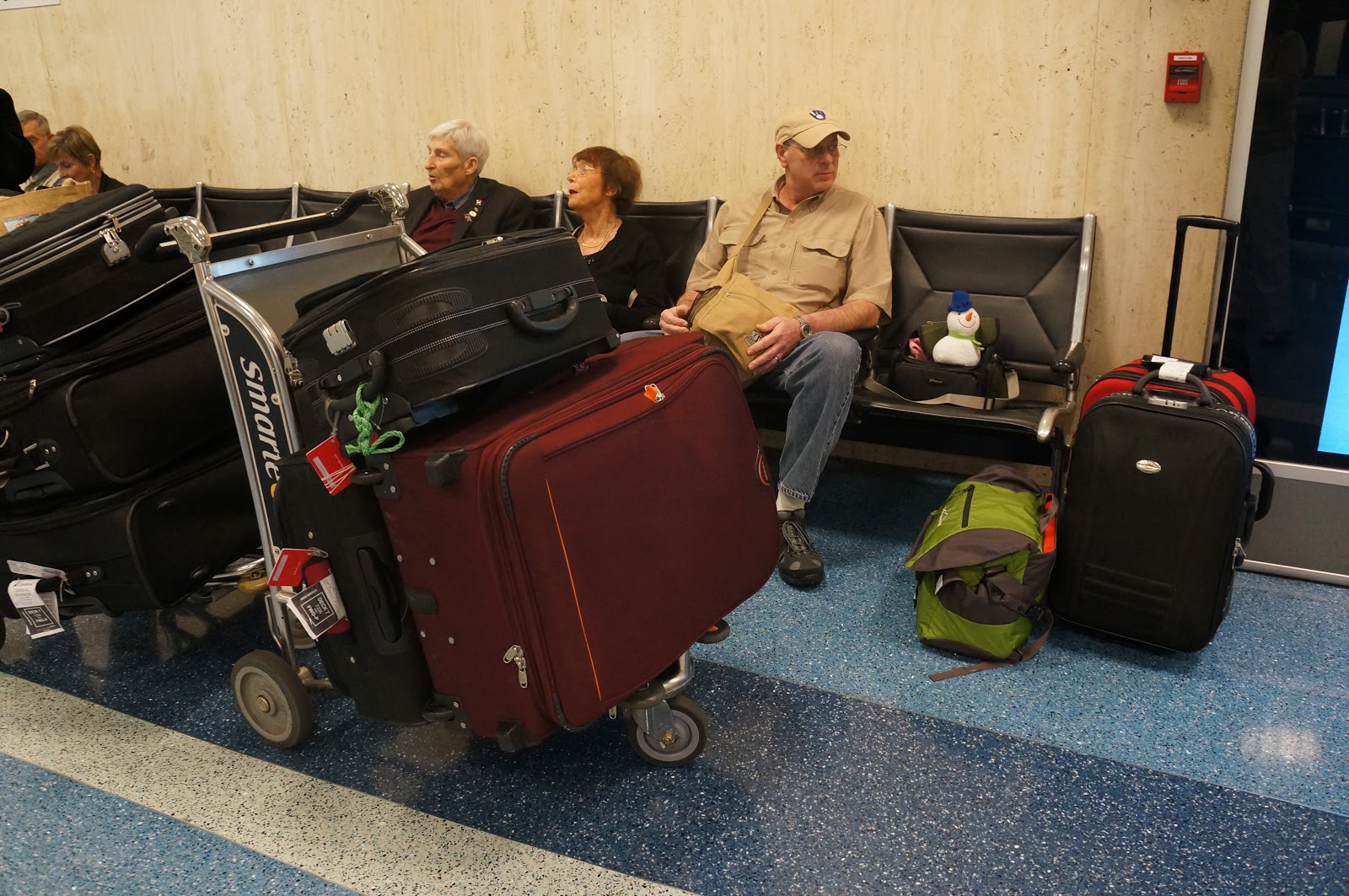
We’ve been visiting with the couple on the left. They are
from St. Johns, Newfoundland, Canada.
The luggage on the two carts in front of them is what they brought for
the cruise. We only brought the bags on the right. Wonder if we forgot
anything!?!
Sunday, February 3, 2013
Beginning of the adventure
2013-2-2
Our bags are packed and we are ready to begin our South
America adventure. The flights were
basically on time and went smoothly. Duane thought the Dallas to LA leg seemed
really long. We have one night in LA before getting on the ship. Travel days
wear us out! Slept well, looking forward to getting on the ship.

Subscribe to:
Posts (Atom)